THINGS have often become explosive in Catalunya. Just as you cross the Pyrénées towards what is now the Costa Brava, you could find out how hot-headed the region was, and how it liked to blow its top.
When thinking about volcanoes in Spain, the Canary Islands tends to be the region which springs to mind – El Hierro has one under the sea just off its coast, which was in constant eruption for about a year and a half and, although it did not cause damage or injury, kept geologists fascinated as they studied its structure and activity. And, of course, there's the Teide National Park – although this is in fact an active volcano, it has not erupted since November 18, 1909, just over 111 years since the previous time, and is not expected to do so again for a long time, if ever. Even if it does, there'll be plenty of time for the tourists exploring it to be moved to safety, and there are no residential areas near enough to be in danger – albeit air travel could well be disrupted over several continents, as was the case with the Icelandic eruptions of Eyjäfjällajökull and Bardárbunga, where the worst of the immediate damage was caused by floods, not lava, as the snow on these mountains melted.
But you probably hadn't realised Catalunya was home to around 50 volcanoes, too.
La Garrocha National Park emerges from earth's crust
The La Garrocha ('La Garrotxa', in catalán)National Park volcanoes are thought to have formed at the end of the Miocene era, around 5.3 million years ago.
A series of fractures started to appear in the westernmost part of what is now the continent of Europe, stretching from the North Sea to the south of mainland Spain and Portugal.
As a result, the magma (hot, molten rock – known as 'lava' once it has broken through the surface) beneath the earth's crust began to rise, taking advantage of the cracks, and creating volcanoes.
This is in fact relatively recent, in geological terms, for volcanoes to form – and this means they are particularly well-preserved, since they have not had time to become eroded by rain and wind, distorting their shape. In fact, the peaks of some of the 50-plus volcanoes in La Garrocha have been used as a site build watchtowers and defence fortresses, and their material extracted for other construction, even as recently as the 1990s, which is the only deterioration they have suffered.
Have they ever erupted? Of course, although long before documented history could tell us much about any inhabitants in the area. They first began to blow their tops around half a million years ago, and continued to do so fairly regularly – centuries apart, but a flash in the pan in the lifespan of a planet – until around 11,500 years ago, at the end of the Palaeolithic era.
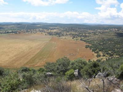
They are now coated in dense, green forest, but can clearly be identified as volcanoes from above, by their huge craters.
If they ever did erupt again, the town of Olot, in the province of Girona, would have to be evacuated – residents get a clear view of the volcanoes from their windows – although 11,500 years after the last episode, the chances of this happening are virtually nil, especially in the lifetime of any human currently on earth.
What to visit and how
La Garrocha became an officially-protected nature reserve in 1982 and, in 1986, was named a National Park, meaning its rare environment of rock formations, flora and fauna enjoy maximum conservation.
Now, it has become a fascinating Mecca for visitors – and a perfect contrast for those who head to the Costa Brava for sunshine and beach relaxation, but want to fit some sightseeing into their holiday.
The youngest of La Garrocha's volcanoes, El Croscat (first picture), which was the last one to erupt – it has exploded twice, the first time being around 17,000 years ago – is one of the most recommended sites to visit within the National Park; day-trippers are taken into its horseshoe-shaped, 350-metre-wide, 600-metre-long crater, where the remains of an ancient watchtower have been found and where you can admire the breathtaking palette of colours: the dark layers of rock inside are the original lava from its two eruptions, although those more exposed have turned a full range of yellows, reds and oranges through oxidation.
Most intriguing of all is a huge 'tongue' of lava, spilling over the edge of the crater and measuring about three kilometres in length.
El Croscat was the last-ever volcano on mainland Spain to erupt, and is relatively easy to reach via several footpaths from the Can Blanc and Santa Pau area.
Olot tourist information office recommends starting any volcano tour from its premises, which takes you through the historic quarter of the town and then up a mountainside path with a 100-metre slope; within 35 minutes, you'll be on the face of the Montsacopa volcano (third picture), which entered into 'minor' eruption for the last time 100,000 years ago, merely bubbling a bit and not causing any damage beyond its immediate crater. The Montsacopa is the easiest in La Garrocha to reach, as the town centre blends into the foot of it, people live in houses right at its base, and between the residential zone and the summit, you'll find the Sant Francesc church and two look-out towers.
Montsacopa's exceptional location and ease of access makes it a highly-popular viewing point over Olot and, on a clear day, you can even see the tips of the Pyrénées.
A shorter route, which avoids most of the old-town lanes, is from Olot cemetery car park; you'll be on the face of the volcano within about 25 minutes.
Whilst there, another must-see feature of Catalunya's volcanic past is the cliffs along the Fluvià river in Castellfollit de la Roca – one of the highest-altitude river valleys in the region, at 50 metres above sea level, it offers a spectacular view of the internal structure of a lava spill: natural columns formed as the molten rock cooled almost appear to have been man-made through a painstaking architectural process.
Other volcanoes in mainland Spain: Calatrava in Ciudad Real
Around the time of the La Garrocha eruptions, volcanic activity was recorded in the province of Ciudad Real, just south of Madrid and at the dead centre of mainland Spain – the Calatrava volcanic massif looks, at first glance, like low-lying hills dotted with clumps of trees and hay-coloured pastures, but in fact is home to at least a dozen fascinating volcanic formations.
Like in La Garrocha, the Calatrava volcano (fourth picture) is not terribly eroded as it is also a 'recent' creation – similar to its Catalunya counterparts, around the end of the Miocene era – and close-up, it is not difficult to make out the unique structures that identify it as a volcanic range, including craters, lava 'tongues' frozen in time and 'rock rings' where molten mud and matter hit the ground and cooled.
Nowadays, you'll often see sheep grazing in the extensive grassy meadows in the crater and on the slopes, and may be able to spot birds of prey – golden eagles are regularly seen in the Calatrava area.
Smaller craters have turned into lagoons which, although dry most of the year, tend to fill up with rainwater and attract species of aquatic freshwater birds and plants during the heart of the winter and late autumn.
Photograph 1: El Croscat, Catalunya's youngest volcano (Carquinyol/Wikimedia Commons)
Photograph 2: General view of La Garrocha National Park (Frivière/Wikimedia Commons)
Photograph 3: Montsacopa volcano above Olot, Girona province (Olot tourist information centre)
Photograph 4: Calatrava volcanic massif in the province of Ciudad Real (Castilla-La Mancha tourism board)