Spain's most beautiful bridges - the perfect autumn 'staycation' road trip
Spain's most beautiful bridges - the perfect autumn 'staycation' road trip
With summer drawing to a close, but plenty of warm weather still on the horizon, this is the perfect time for those without school-age kids to hit the road and explore some of Spain's most picturesque locations.
One of the architectural staples in many Spanish towns and cities are the bridges - both ancient and modern. Some of them are so iconic they attract hordes of visitors from far and wide every year; others are less well known, but no less worth a visit if you’re prepared to go a little off the beaten track.
Our road trip starts in Spain's largest autonomous community - Andalusia - specifically in the historic city of Córdoba, then travelling out to Granada, before moving southwards and westwards. Province after province in this region has bridges worthy of a road trip detour. One or two are not for the faint hearted, but the rest are easily accessible to anyone.
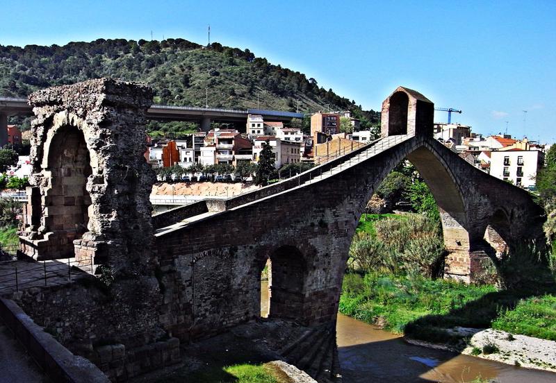
Córdoba - Puente Romano
Puente Romano, Córdoba - photo credit - OK Diario
Spanning the Guadalquivir river, Córdoba’s Roman Bridge was originally built by the Romans in the early 1st century BC. It is thought that the Via Augusta, which connected Rome to Cádiz, most likely passed through it in its original form. Its current shape dates from the Islamic reconstruction in the 8th century, when the city’s Muslim governor, Al-Samh ibn Malik al-Khawlani, ordered a bridge to be built on the ruins of what was left of the old Roman construction. The result is an elegant structure with 16 arcades, reflecting the famous Arab architecture that dominates Córdoba’s famous scenery. In the Middle Ages, the Calahorra Tower and the Puerta del Puente were built at the bridge's southern and northern ends respectively (the latter is now a 16th-century reconstruction). In the 17th century, a sculpture depicting St. Raphael by Bernabé Gómez del Río was erected in the middle of the bridge. It has been reconstructed and expanded many times since then, with the latest restoration work being completed at the start of 2008. It is now 247 metres long and about nine metres wide and these days it is only open to pedestrians and cyclists. It is also known locally as the Old Bridge because for two thousand years, until the construction of the San Rafael Bridge in the mid-twentieth century, it was the city's only bridge across the river. It forms part of the historic centre of Córdoba, which was declared a World Heritage Site in 1984.
Monachil (Granada) - Los Cahorros hanging bridges
One of Los Cahorros hanging bridges - photo credit – verpueblos.com
The spectacular Los Cahorros gorge lies just a couple of kilometres away from the village of Monachil, right on the edge of the stunning Sierra Nevada. With its steep limestone cliffs, the gorge has been popular with climbers for many years but is now gaining popularity amongst hikers. Lush vegetation lines the route – almond, olive, and juniper trees rise up from a bed of lavender, rosemary, thyme, broom and hawthorn bushes, rock roses and other wildflowers, making it particularly attractive in springtime. The hanging bridges add an element of excitement to this walking route, which follows a stretch of the Monachil river, as it winds its way down from the Veleta peak, high up in the Sierra Nevada, culminating in fresh waterfalls. There are four bridges in total and the longest one, suspended over 15 metres above the river, has a span of some 55 metres. Those who suffer from vertigo may think twice about crossing them though as they have a tendency to sway!
El Chorro (Málaga) – Caminito del Rey
El Caminito del Rey - photo credit – turismo.antquera.es
El Caminito del Rey (literally the King’s Little Path) is a narrow walkway along the steep walls of a narrow gorge called El Chorro, near Ardales in the popular province of Málaga. The walkway was originally built to provide workers at the hydroelectric power plants at Chorro Falls and Gaitanejo Falls with a means to cross between them, to provide for transport of materials, and to help facilitate inspection and maintenance of the channel. Construction began in 1901 and was finished in 1905. King Alfonso XIII crossed the walkway in 1921 for the inauguration of the Conde del Guadalhorce dam, and it thus became known by its present name. It is only 1 metre wide and rises over 100 metres above the river below. The original path was constructed of concrete and rested on steel rails supported by stanchions built at approximately 45 degrees into the rock face. It deteriorated over the years, and there were numerous sections where part or all of the concrete top had collapsed. The result was large open-air gaps bridged only by narrow steel beams or other supports. Few of the original handrails existed and although a safety wire ran the length of the path, several people lost their lives on the walkway. After two fatal accidents in 1999 and 2000, the local government closed both entrances and the path fell into total disrepair. After extensive restoration work, the walkway reopened in March 2015, and the new pathway still offers a walk of 2.9 km along the side of the gorge. Just seeing the bridge from a distance and contemplating the surrounding landscape makes it worth visiting this spectacular spot in Málaga, a magnet for professional climbers from around the world.
Possibly the most famous bridge in Spain, Ronda's New Bridge is the most recent and largest of three bridges that spanned the 120-metre-deep El Tajo gorge that divides the city into two halves. The construction of this newest bridge was started in 1759 and took 34 years. There is a chamber above the central arch that has been used for a variety of purposes over the years, including as a prison. During the 1936–1939 civil war both sides allegedly used the prison as a torture chamber for captured opponents, killing some by throwing them from the windows to the rocks at the bottom of the El Tajo gorge. Construction of the previous bridge, the first attempt to span the gorge at this height, was started in 1735. Unfortunately, that single-arch bridge was quickly and poorly built and collapsed in its entirety in 1741, killing 50 people.
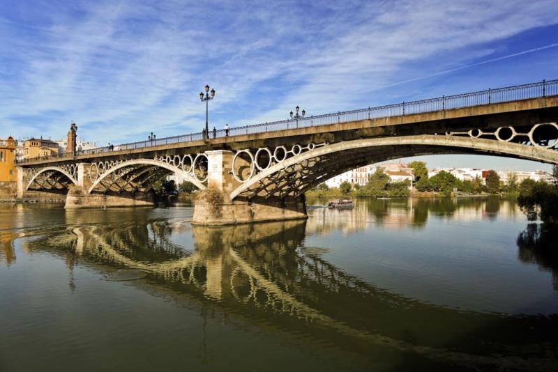
Seville – Puente de Triana
Puente de Triana - photo credit – guiasevilla.com
The Triana Bridge, also known as the Puente de Isabel II (Elizabeth II Bridge) is a metal arch bridge completed in 1852 that connects the Triana neighbourhood with the centre of Seville. It was first built as a floating (pontoon) bridge by the Moors in the 12th century, but eventually replaced seven centuries later by the current structure. Triana stands on a peninsula between two branches of the Guadalquivir river, narrowly linked to the mainland in the north. Triana has a traditional pottery and tile industry, a vibrant flamenco culture, and its own festival. It has played an important role in the development of Sevillan culture and tradition.
Seville – Puente de Alamillo
Puente del Alamillo - photo credit - Wikipedia
In sharp contrast to the 19th century Triana bridge, the Alamillo Bridge is both modern and dramatic. Spanning the Canal de Alfonso XIII and allowing access to La Cartuja, a peninsula located between the canal and the Guadalquivir River, the bridge was constructed as part of infrastructure improvements for Expo 92, which was held on large banana farms on the island. From a design by the world-renowned Valencian architect Santiago Calatrava, construction of the bridge began in 1989 and was completed in 1992. The artistic concept can be traced back to a 1986 sculpture by Calatrava entitled 'Running Torso', in which inclined stacked marble cubes are balanced by a tensioned wire. The Alamillo Bridge consists of a single straight steel-shell tower, infilled with reinforced concrete and inclined backward, counterbalancing a 200 metre span with thirteen pairs of cables. The original intention was to build two symmetrical bridges on either side of the island, but in the end the Alamillo's singular asymmetric design has proved most striking.
Almonaster (Huelva) - Puente de las Tres Fuentes
Puente de las Tres Fuentes, Almonaster - photo credit – atrapahuelva.com
The Bridge of Three Fountains in Almonaster la Real (Huelva) forms part of the Huelva-Zafra railway line and was designed by disciples of the renowned French engineer, Gustave Eiffel. Linking two tunnels, it is part of a viaduct that was originally built out of iron, but then coated in concrete in the mid-twentieth century. It is 160 metres long and stands on the banks of the narrow La Lisa river which are adorned with holly oaks, poplars and cork oaks and are home to barn owls and wild boar.
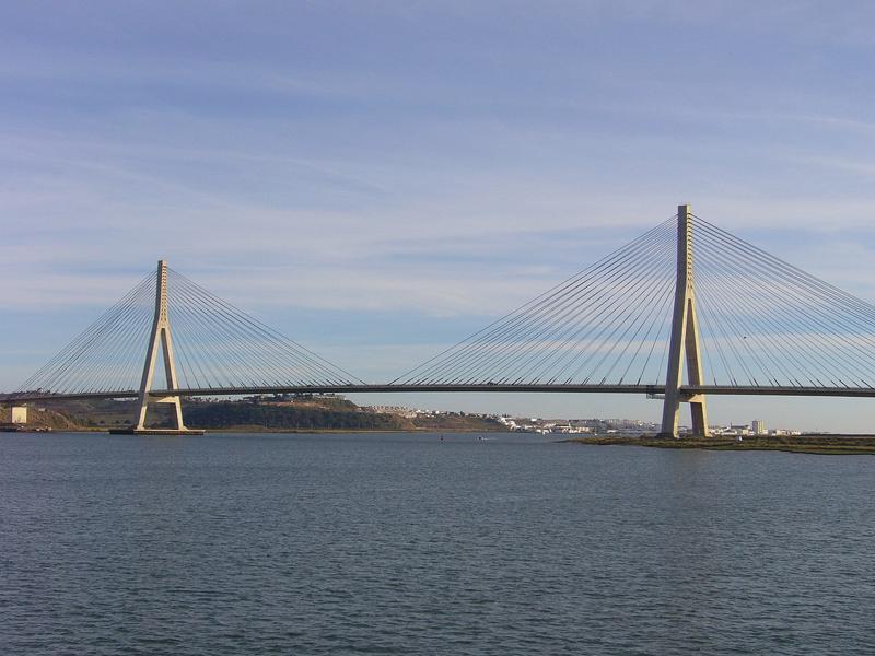
Ayamonte (Huelva) – Puente Internacional del Guadiana
Puente Internacional del Guadiana, Ayamonte - photo credit - Roger W. Haworth
The Guadiana International Bridge (Spanish: Puente Internacional del Guadiana; Portuguese: Ponte Internacional do Guadiana) is a bridge across the Guadiana River connecting southern Spain (town of Ayamonte) with Portugal (town of Castro Marim). It is the southernmost land crossing on the Portugal–Spain border, with the majority of the bridge in Portugal. Completed in 1991, its structural type is a cable-stayed bridge, with a deck of prestressed concrete. The bridge was designed by the Portuguese Structural Engineer Professor José Luis Câncio Martins. Open only to vehicle, it is the third longest bridge in Portugal and one of the longest in Spain, with a total span of 666 metres and a central span between the towers of 324 metres. The deck stands 20 metres above the river. The two towers of the bridge are 95 and 96 metres tall, respectively. The tower on the Spanish side rests on an artificial island built on the riverbed, while the pillar on the Portuguese side is on land.
Travelling northwards from Huelva we reach the little-known province of Badajoz. This area of Spain is not usually high up on the list of tourist locations, but not only does it give easy access for trips over the border into Portugal, it also hides one of Spain's best-kept secrets - the city of Mérida, with its Roman amphitheatres, temples and, of course, bridges.
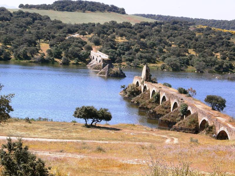
Olivenza (Badajoz) – Puente de Ayuda
Puente de Ayuda, Olivenza - photo credit – Adolfobrigido
The Bridge of Ajuda (in Portuguese: Ponte de Nossa Senhora da Ajuda, Spanish: Puente de Nuestra Señora de Ayuda) is a bridge that crosses the Guadiana River between Elvas in Portugal and Olivenza in the Spanish province of Badajoz. The bridge was constructed between 1520 and 1521, during the reign of King D. Manuel I of Portugal from the left bank of the Guadiana, in the parish of Senhora da Ajuda, along a roadway segment between Elvas and Olivenza. During 1597, many of the archways were damaged or destroyed during flooding. It is possible that the bridge was rebuilt between 1640 and 1642 when general refortifications were carried out around Olivença (then part of Portugal). It was partially destroyed by Spanish forces in 1657, only to be rebuilt again later that same century. After being reinforced during the early years of the 18th century, it was partially demolished by artillery during the War of the Spanish Succession in 1709. The Spanish army, under the command of D. Manuel Godoy annexed the town of Olivença in 1801. In 1967 the Portuguese government declared the bridge a Property of Public Interest. The Spanish government finally gave it the same recognition in 2009. The bridge is located in a rural environment, isolated and encircled by wild vegetation, approximately 100 metres from the Chapel of Nossa Senhora da Ajuda, along a segment of abandoned road 12 kilometres between Elvas and Olivenza. Although now a ruin, the bridge was once 453 metres long and 5 metres wide, with a platform that was at most 161 metres above the river.
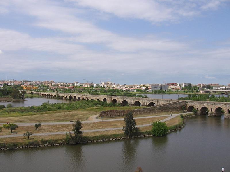
Mérida (Badajoz) – Puente Romano
Puente Romano, Mérida - photo credit - Ardo Beltz
Mérida’s Roman Bridge is the longest bridge in the world to have survived from ancient times, having once boasted an overall length of 755 metres with 62 spans. Today there are 60 spans, three of which are buried on the south bank of the Guadiana river, and it measures 721 metres between abutments. The bridge forms part of Mérida’s archaeological ensemble which was declared a UNESCO World Heritage Site in 1993. It was pedestrianised in 1991 as road traffic was redirected to the nearby Lusitania Bridge. Annexed to the bridge is the Alcazaba of Mérida, a Moorish fortification built in 835. Mérida is also home to another Roman bridge - the much smaller Puente de Albarregas - close to the remains of the Acueducto de los Milagros.
Northwards from Badajoz we come to the beautiful ancient city of Salamanca, which not only has two of the finest cathedrals in the land, but also has some of its own Roman heritage to boast about.
Salamanca’s Roman bridge, also known as Puente Mayor del Tormes, has been an important symbol of the city for many centuries and figures in the first quartering of city's coat of arms (along with its stone bull). The date of the construction of the bridge is not precisely known but is among the mandates of the Emperors Augustus (27 B. C.-14 D. C.) and Vespasian (69-79), making it a bi-millennium architectural monument. The bridge is actually constructed of two bridges separated by a central fortification: the old bridge which extends along the portion near the city and is of Roman origin, and the new bridge. Of the twenty-six arches, only the first fifteen date from Roman times. The bridge has been restored numerous times, in particular after the Flood of San Policarpo on the night of January 26th 1626, and has survived several attempts at demolition. It was declared an Artistic Historic Monument in 1931, and a Property of Cultural Interest in 1998. Until the beginning of 20th century it carried the main road into the city and continued to bear heavy traffic until 1973. After the construction of a third bridge for road traffic is now for the exclusive use of pedestrians.
Less than an hour's drive north of Salamanca brings you to the stately city of Zamora, best known for its spectacular Holy Week processions.
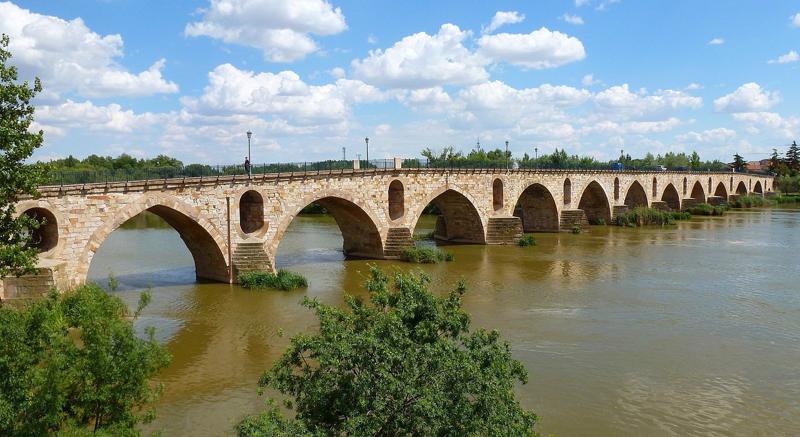
Zamora – Puente de Piedra
Puente de Piedra, Zamora - Photo credit - Outisnn
The Stone Bridge in Zamora (known as the New Bridge in the Middle Ages) is one of five bridges that cross the river Duero as it flows through this provincial capital. For centuries it was the only way to cross the river from the historic city centre to the suburb on the other side and has long been a symbol of the city. Owing to its strategic location on the Vía de la Plata (Silver Way) trading route it was an important river Duero crossing point for people, merchandise and livestock. Construction was completed at the beginning of the 13th century and renovated many times since, with the most radical changes being carried out at the beginning of the 20th century. Sadly, many of the ornamental elements of the bridge were removed at this point, including the towers at either end of the bridge, to give greater access to the ever-increasing volume of traffic. With the opening of the Puente de Poetas (Poets’ Bridge) in 2013, the Stone Bridge was limited to pedestrian traffic only and remains so today.
Travelling sout-eastwards from Zamora, towards the middle of the country, brings you to one of the ‘must-see’ places in Spain - Segovia. Alongside a fairytale castle, a gorgeous cathedral and a fascinating Jewish quarter stands one of Spain's most recognisable and popular monuments:
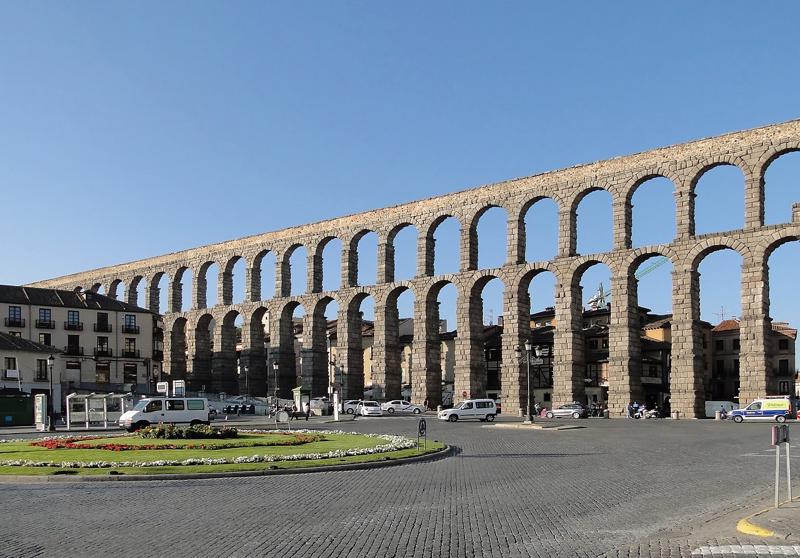
Segovia – Acueducto de Segovia
Segovia Aqueduct - photo credit - Bernard Gagnon
The Aqueduct of Segovia is one of the best-preserved elevated Roman aqueducts in the world and the foremost symbol of Segovia. It is a UNESCO World Heritage Site. The aqueduct once transported water from the Rio Frio river, situated in mountains 17 km from the city in the La Acebeda region. It runs 15 km before arriving in the city. As the aqueduct lacks a legible inscription, the date of construction cannot be definitively determined, although it was thought to have been during the 1st century AD, during the reigns of the Emperors Domitian, Nerva, and Trajan. Scholars' best estimates place the completion of construction somewhere between 98 AD and 117 AD. At its tallest, the aqueduct reaches a height of 28.5 metres, including nearly 6 metres of foundation. There are both single and double arches supported by pillars. From the point the aqueduct enters the city until it reaches Plaza de Díaz Sanz, it includes 75 single arches and 44 double arches (or 88 arches when counted individually), followed by four single arches, totalling 167 arches in all. The aqueduct is the city's most important architectural landmark. It was kept functioning throughout the centuries and has been preserved in excellent condition, providing water to Segovia until the mid-19th century.
Heading north-east of Segovia, through the beautiful cathedral city of Burgos and on until nearly on the French border, we come to our next picturesque bridge, in the village of Gares.
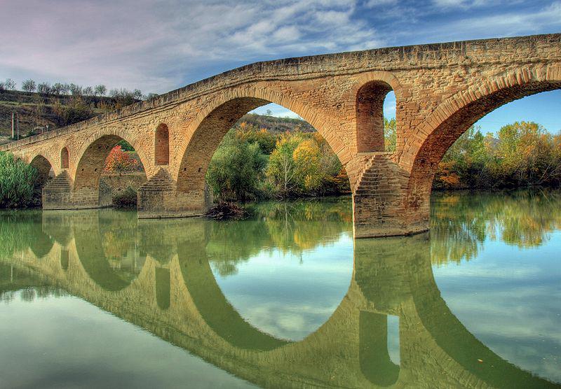
Gares (Navarre) – Puente la Reina
Puente la Reina, Gares - photo credit - Wikipedia
Puente la Reina (Queen’s Bridge) can be found in the small town of Gares in the province of Navarre in northern Spain. Queen Muniadona, wife of King Sancho III, gave her name to this bridge, also known as the Puente Románico. She had the 110 metre, six-arched Romanesque bridge built over the river Arga in the 11th century for pilgrims to use on their way to Santiago de Compostela along the Camino de Santiago (Way of St. James Pilgrimage route). Gares is the first town after the junction of the French Way (the most popular route) and the Aragonese Way. In the centre of the bridge there was a niche with the stone carving of the Virgin of Puy, known as Txori and which is currently in the church of Santiago. Legend has it that a little bird used to visit her every day, to keep her clean with its beak so she would keep people safe on the bridge, but the day the carving was moved, a man died falling from the bridge.
Back out towards the Mediterranean coast, passing through another famous cathedral city - Zaragoza - and then Lleida, we eventually come to the small, but perfectly formed village of Besalú.
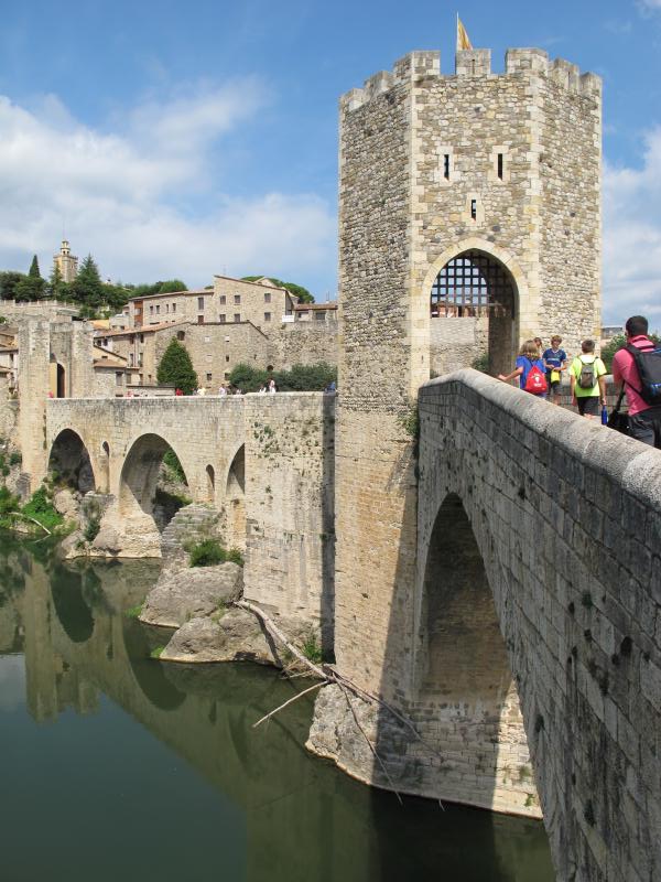
Besalú (Gerona) – Puente de Besalú
Pont de Besalú - photo credit - Igor González Martín (Madrid)
The Besalú bridge (Pont de Besalú in Catalan) is a Romanesque bridge over the river Fluviá located in the picturesque Gerona village of the same name. It is deemed a Property of Cultural Interest at both national and regional levels. It is an angular bridge with seven unequal arches on top of pillars, many of them built on rock, with cutwaters. A fortified, hexagonal gateway sits atop the first pillar of the bridge. The bridge is the result of several reconstructions, but it is first recorded in local records in the year 1075. There is a heraldic stone on one of the pillars with the date 1680, which suggests a major restoration or an almost total reconstruction of the bridge. Several other changes or repairs have been recorded since then. In 1880 the central tower and the access portal from the town were demolished to facilitate the passage of machinery necessary for local industry and then in 1939, during the Spanish Civil War, two arches were blown up and were subsequently replaced.
Heading down the Mediterranean coast, our next stop is the Catalonian village of Martorell.
Martorell (Catalonia) – Puente del Diablo
Pont del Diable, Martorell - photo credit Jaume Meneses - Flickr: Catalunya - Baix Llobregat
Devils’ Bridge (Pont del Diable in Catalan) links the towns of Martorell and Castellbisbal across the river Llobregat. Of Roman origin, it was built in around 10 BC as part of the Via Augusta to carry oxcarts from one side of the river to the other. Today’s 130-metre-long bridge is a 1963 reconstruction of a gothic bridge dating back to the end of the 13th century, but it conserves the original Roman abutments with inscriptions of the legions that worked (legions X Gemina, IV Macedonica and VI Victrix), and a triumphal arch on the left bank, probably from the second century. Until the 14th century it was the only bridge in the lower Llobregat valley. The original bridge was destroyed by floodwaters and reconstructed in 1143. It was later rebuilt as a Gothic bridge with a tall, single arch to avoid the effect of floods. Work on this version began in 1283 and finished in 1295. In January 1939 the central arch was destroyed by the retreating People's Army of the Republic at the end of the Spanish Civil War, being rebuilt in 1963, maintaining the Gothic structure of the 1283 reform.
Continuing our journey down the Mediterranean coast, no architectural road trip would be complete without a visit to Spain's third largest city - the stylish coastal city of Valencia.
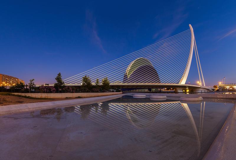
Valencia – Pont de l’Assut de l’Or
Pont de l'Assut de l'Or, Valencia - photo credit - Diego Delso
The Assut de l'Or Bridge (Valencian: Pont de l'Assut de l'Or, Spanish: Puente de la Presa del Oro) is a white single-pylon cable-stayed bridge in the ultra-modern City of Arts and Sciences in Valencia. It is another work by Valencian architect and civil engineer Santiago Calatrava and was completed in December 2008. The name l'Assut de l'Or is Valencian for the Dam of the Gold and refers to a dam that was located nearby, although locally it is referred to as El Jamonero (The Ham Holder) or Puente del Arpa (The Harp Bridge). It is a popular stop on sightseeing tours of the beautiful Mediterranean city of Valencia.
Our trip ends with a short trip inland to the often ignored province of Albacete.
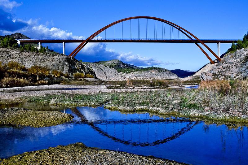
Yeste (Albacete) – Puente de la Vicaria
Puente de la Vicaría, Yeste - photo credit - Luis Martin Tereso (Wikipedia)
The eye-catching Vicaria Bridge is a modern, through-arch bridge that spans the Segura River, where it meets La Fuensanta Reservoir near Yeste, in the province of Albacete. In the 1930s, after the Segura River was dammed to create the Fuensante Reservoir, the town of Yeste, the main town in this isolated and mountainous region of Albacete, was split in half. Roads connecting it with neighbouring towns and villages disappeared underwater, obliging the locals to circumnavigate the reservoir, adding many kilometres and almost an hour to their journeys. At the time the hydrographic company said it would reconnect these villages, but it took more than 70 years to honour that promise. The 168 metre Vicaría bridge, built of steel and reinforced concrete, with approaching spans, takes advantage of this beautiful valley’s natural morphology and the width of the reservoir at this point. The foundations of the arches rest on the limestone rock on both hillsides at the reservoir’s high water level.